Keyline Design: Read Your Land’s Water Story
Every piece of land tells a story through water. Keyline design is the fundamental permaculture technique that helps you read this story and work with nature’s flow patterns instead of fighting them. By understanding how water moves across your property, you’ll position swales, plantings, and pathways to maximize retention and create a thriving ecosystem.
Whether you’re working with a quarter-acre suburban lot or several rural acres, learning to identify ridge lines and water flow patterns transforms how you design your space. This approach saves time, money, and creates more resilient growing systems.
What Is Keyline Design and Why Does It Matter?
Keyline design originated in Australia as a method for managing water on large farming properties. The system identifies the “keyline” – the point where a ridge transitions from convex to concave slopes. This critical junction determines how water flows and where it naturally wants to collect.
For home gardeners, keyline design principles help you:
- Reduce erosion and soil loss
- Capture and store rainwater naturally
- Create microclimates for diverse plantings
- Position infrastructure logically
- Build fertility through water management
Think of it as reading your land’s natural blueprint. Once you understand the water story, every design decision becomes clearer.
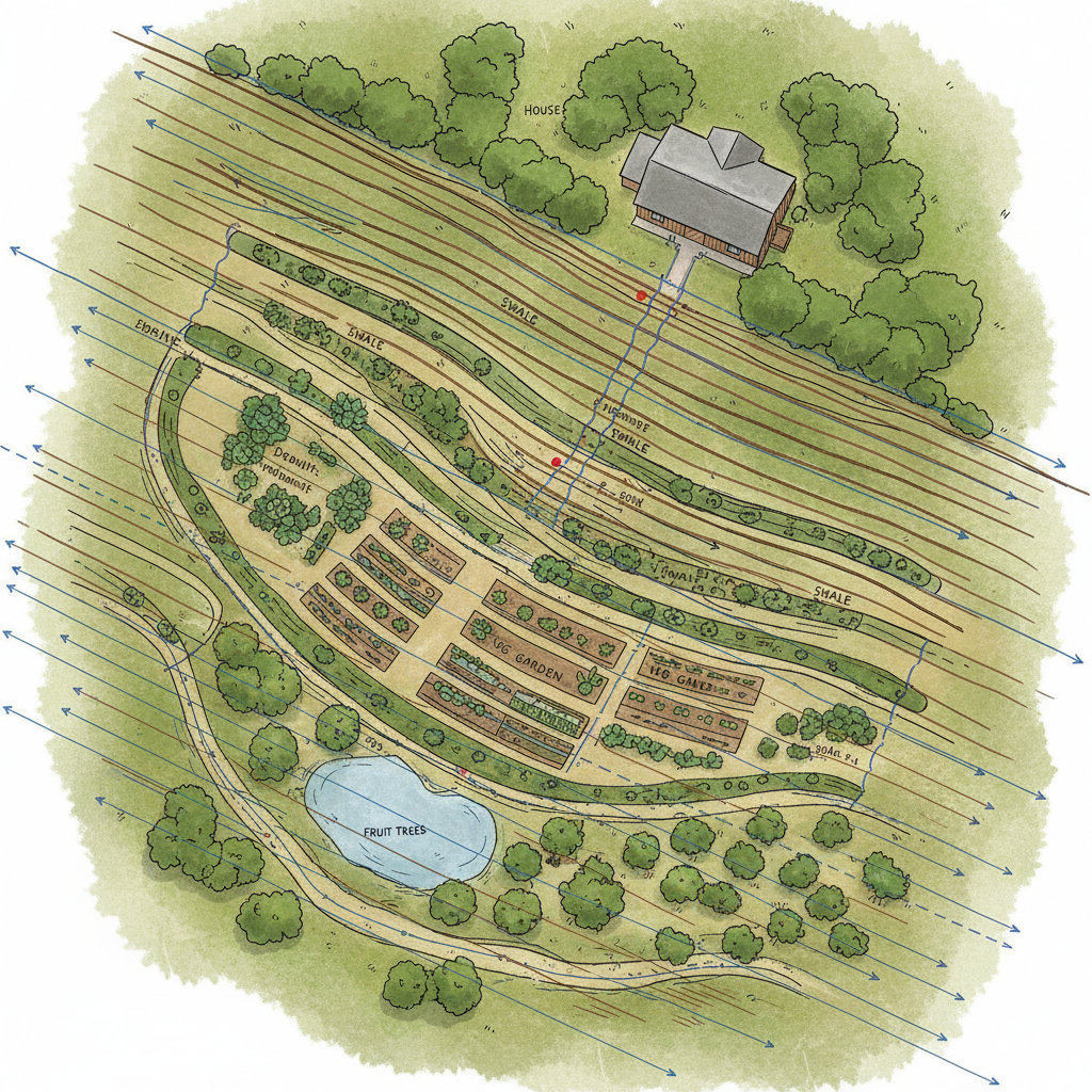
Reading Your Property’s Ridge Lines and Valleys
Start your keyline design journey by walking your property after a good rain. Water reveals the truth about your landscape’s contours and drainage patterns.
Identifying Ridge Lines
Ridge lines are the high points where water naturally divides and flows in different directions. These might be obvious hills or subtle raised areas in otherwise flat terrain.
Look for:
- Areas that stay dry longest after rain
- Places where runoff splits and flows away
- Gentle rises that shed water to either side
Even in flat yards, micro-ridges exist. A gentle slope from your house foundation or a slightly elevated garden bed creates the same water-dividing effect.
Mapping Valley Lines
Valley lines collect water from surrounding slopes. These are your natural retention and infiltration zones.
Watch for:
- Areas that stay muddy longest
- Natural depressions where debris collects
- Paths worn by flowing water
- Lusher vegetation indicating more moisture
Your microclimate mapping efforts work hand-in-hand with water flow observation to create a complete picture of your growing environment.
Finding Your Property’s Keyline Points
The keyline point sits where a ridge’s steep slope begins to flatten into a gentler valley. This transition zone offers the best opportunities for water capture and control.
To locate keyline points:
- Stand at the bottom of a slope and look uphill
- Identify where the slope changes from steep to gentle
- Mark this transition zone – that’s your keyline
- Repeat for each ridge-valley system on your property
In suburban settings, keyline points might be where your sloped driveway meets level ground, or where a gentle rise in your backyard transitions to flatter lawn area.
Tools for Better Observation
While you can identify basic patterns with just your eyes and feet, simple tools enhance accuracy:
- A-frame level for checking subtle slopes
- Stakes and string for marking contours
- Smartphone apps that show elevation changes
- Garden hose to test water flow directions
Remember, precision matters less than understanding general patterns. Start simple and refine your observations over time.
Keyline Design Principles for Water Management
Keyline design follows specific principles that guide where and how you intervene in natural water flows.
Slow, Spread, and Sink
The three S’s of water management work together:
Slow: Reduce water velocity with vegetation, terraces, or strategically placed rocks. Fast-moving water erodes soil and carries nutrients away.
Spread: Distribute concentrated flows across wider areas. This prevents erosion channels and gives water more time to infiltrate.
Sink: Capture water in the landscape through swales, basins, and improved soil structure.
Work Above the Keyline
Above keyline points, direct water along contours to spread it across slopes. This prevents erosion and keeps water in the landscape longer.
Below keyline points, direct water downhill to prevent waterlogging while still capturing what you can in strategically placed swales or rain gardens.
Just like your soil diagnostics inform your amendment strategy, water flow analysis guides your infrastructure placement.
Practical Applications in Home Gardens
Translating keyline design principles into actionable garden improvements doesn’t require heavy machinery or major earthworks.
Positioning Swales and Berms
Place swales (depressions) along contour lines above keyline points to spread water across slopes. Position berms (raised areas) to direct flow toward desired locations.
In small spaces, even subtle berms made from compost and mulch can redirect roof runoff toward thirsty plantings instead of into storm drains.
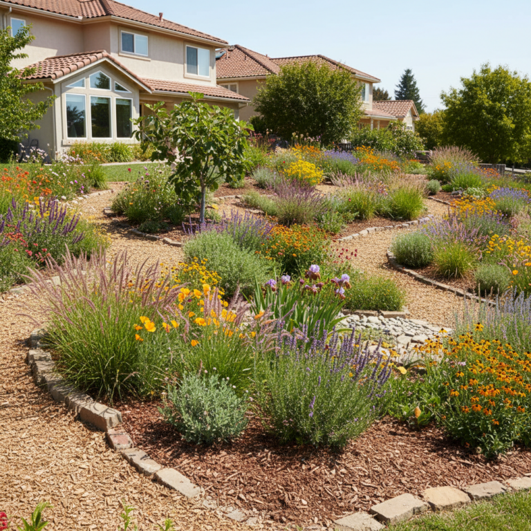
Strategic Plant Placement
Use your water flow knowledge to match plants with their preferred moisture levels:
- Place water-loving plants in valley lines and below keylines
- Position drought-tolerant species on ridges and well-drained slopes
- Create transition zones with plants that handle variable moisture
This natural placement reduces watering needs and creates more resilient plantings. Your microclimate-aware planting approach becomes even more effective when combined with water flow awareness.
Path and Infrastructure Planning
Design pathways to follow ridge lines where possible. This keeps foot traffic on naturally drier ground and preserves moisture-holding valley areas for plants.
Position water-sensitive infrastructure like tool storage or seating areas on well-drained ridges, while locating rain barrels and composting areas where they can benefit from natural water flow.
Building Your Keyline Design Action Plan
Transform your water flow observations into concrete improvements with this systematic approach:
Phase 1: Observation and Mapping
Spend a full season observing water patterns during different weather events. Heavy rains, gentle showers, and snowmelt all reveal different aspects of your land’s water story.
Create a simple sketch map showing:
- Major ridge and valley lines
- Keyline points
- Current water problems (erosion, pooling, dry spots)
- Existing infrastructure and plantings
Phase 2: Small-Scale Interventions
Start with low-cost, reversible changes:
- Redirect downspouts to beneficial locations
- Create small swales using just a shovel
- Add mulch berms to guide water flow
- Plant water-loving species in identified wet spots
These initial interventions help you understand how your land responds to changes and refine your approach.
Phase 3: Larger Improvements
Once you’ve tested smaller changes, consider more substantial improvements:
- Installing formal rain gardens or bioswales
- Reshaping slopes for better water capture
- Adding terraces or retaining walls
- Creating dedicated wet and dry garden zones
Common Keyline Design Mistakes to Avoid
Learning from others’ experiences accelerates your success with keyline design implementation.
Rushing the observation phase: Spend adequate time watching water behavior before making major changes. Quick fixes often create new problems.
Ignoring existing drainage: Work with your property’s natural patterns rather than fighting them. Forcing water to go where it doesn’t want to go rarely succeeds long-term.
Over-engineering solutions: Simple interventions often work better than complex systems. Start small and build complexity gradually.
Forgetting maintenance needs: Design systems you can realistically maintain. A simple swale you’ll keep clear works better than an elaborate system you’ll neglect.
Seasonal Considerations for Water Management
Your keyline design strategy should account for seasonal water patterns and garden needs throughout the year.
Spring: Focus on managing snowmelt and early rains. This is often your biggest water management challenge and greatest opportunity for soil recharge.
Summer: Maximize stored water efficiency and create cool, moist microclimates in valley areas.
Fall: Prepare systems for winter runoff and use autumn rains to establish new plantings in water-strategic locations.
Winter: Plan improvements and observe how dormant season water movement differs from growing season patterns.
Conclusion: Your Water-Wise Garden Transformation
Mastering keyline design principles transforms your relationship with your land. Instead of fighting natural water flows, you’ll work as nature’s partner to create more productive, resilient growing spaces.
Start with careful observation during your next rainfall. Notice where water wants to go and how your landscape responds. These observations become the foundation for design decisions that save water, prevent erosion, and create thriving microclimates.
Remember, keyline design is a skill that develops over time. Each season brings new insights about your land’s water story. Embrace the learning process and celebrate small improvements that compound into major landscape transformations.
Your thoughtful approach to water management creates the foundation for all other permaculture principles to flourish in your garden ecosystem.